
Shemesh Viewpoint topographic map
Click on the map to display elevation.
About this map
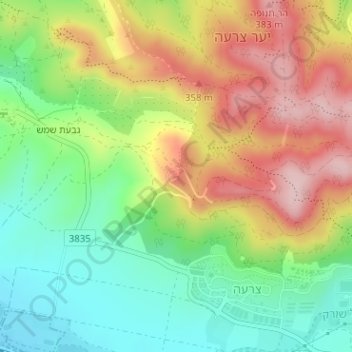
Name: Shemesh Viewpoint topographic map, elevation, terrain.
Average elevation: 873 ft
Minimum elevation: 518 ft
Maximum elevation: 1,312 ft
Other topographic maps
Click on a map to view its topography, its elevation and its terrain.
Netiv HaLamed He
Israel > Jerusalem District > Mate Yehuda Regional Council
Average elevation: 1,102 ft
Maale HaHamisha
Israel > Jerusalem District > Mate Yehuda Regional Council
Average elevation: 2,369 ft
Givat Yeshayahu
Israel > Jerusalem District > Mate Yehuda Regional Council
Average elevation: 1,017 ft