Geolocate

Bullard topographic map

Click on the map to display elevation.

About this map

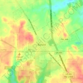
Name: Bullard topographic map, elevation, terrain.

Location: Bullard, Smith County, Texas, United States (32.11965 -95.35435 32.16512 -95.28931)

Average elevation: 502 ft

Minimum elevation: 387 ft

Maximum elevation: 604 ft

Smith County trails, hiking, mountain biking, running and outdoor activities

Other topographic maps

Click on a map to view its topography, its elevation and its terrain.

Swan

United States > Texas > Smith County

Average elevation: 512 ft

Thedford

United States > Texas > Smith County > Lindale

Average elevation: 509 ft

Fun Forest Park

United States > Texas > Smith County > Tyler

Average elevation: 535 ft

Owentown

United States > Texas > Smith County

Average elevation: 397 ft

Whitehouse

United States > Texas > Smith County

Average elevation: 466 ft

Pine Springs

United States > Texas > Smith County > Tyler > Pine Springs

Average elevation: 509 ft

Tyler

United States > Texas > Smith County

Average elevation: 482 ft

Gear up for your next adventure:

🪶Compact Camp Shovel - Folding shovel for campsite tasks
🖼️Topo Map Wall Art - Decorative topographic prints of famous peaks and regions
🔭Compact Binoculars - HD vision for scouting terrain and identifying distant landmarks
🍳Camping Cook Set - Complete cookware for outdoor meals
🪑Ultralight Camp Chairs - Portable seating for resting after a long day of mapping

As an Amazon Associate, this site earns from qualifying purchases at no extra cost to you.