
Make a donation
Gear up for your next adventure:
As an Amazon Associate, this site earns from qualifying purchases at no extra cost to you.
Adelboden topographic map
Click on the map to display elevation.
Make a donation
Gear up for your next adventure:
As an Amazon Associate, this site earns from qualifying purchases at no extra cost to you.
About this map
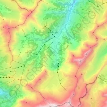
Name: Adelboden topographic map, elevation, terrain.
Average elevation: 6,437 ft
Minimum elevation: 3,451 ft
Maximum elevation: 10,607 ft
Make a donation
Gear up for your next adventure:
As an Amazon Associate, this site earns from qualifying purchases at no extra cost to you.
Other topographic maps
Click on a map to view its topography, its elevation and its terrain.
Oeschinen Lake
Switzerland > Bern > Frutigen-Niedersimmental administrative district > Kandersteg
Oeschinen Lake (German: Oeschinensee) is a lake in the Bernese Oberland, Switzerland, 4 kilometres (2.5 mi) east of Kandersteg in the Oeschinen valley. At an elevation of 1,578 metres (5,177 ft), it has a surface area of 1.1147 square kilometres (0.4304 sq mi). Its maximum depth is 56 metres (184 ft).
Average elevation: 6,293 ft
Kiental
Switzerland > Bern > Frutigen-Niedersimmental administrative district > Reichenbach im Kandertal
Since 1910, the nearby mountain of Niesen (altitude 2,362 m [7,749 ft]) can be ascended at gradients of up to 68% via the Niesenbahn, which with a length of 3,499 m (11,480 ft) is the longest funicular railway in Europe.
Average elevation: 4,951 ft
Fürten
Switzerland > Bern > Frutigen-Niedersimmental administrative district > Kandergrund
Average elevation: 4,600 ft
Faulensee
Switzerland > Bern > Frutigen-Niedersimmental administrative district > Spiez
Average elevation: 2,093 ft
Make a donation
Gear up for your next adventure:
As an Amazon Associate, this site earns from qualifying purchases at no extra cost to you.
Griesalp
Switzerland > Bern > Frutigen-Niedersimmental administrative district > Reichenbach im Kandertal
Average elevation: 5,676 ft
Hockenhorn
Switzerland > Bern > Frutigen-Niedersimmental administrative district > Kandersteg
Average elevation: 8,527 ft
Hockenhorn
Switzerland > Bern > Frutigen-Niedersimmental administrative district > Kandersteg
Average elevation: 8,527 ft
Reichenbach im Kandertal
Switzerland > Bern > Frutigen-Niedersimmental administrative district
Average elevation: 6,253 ft
Make a donation
Gear up for your next adventure:
As an Amazon Associate, this site earns from qualifying purchases at no extra cost to you.
Steghorn
Switzerland > Bern > Frutigen-Niedersimmental administrative district > Adelboden
Average elevation: 8,638 ft
Blausee
Switzerland > Bern > Frutigen-Niedersimmental administrative district > Kandergrund > Blausee-Mitholz
Average elevation: 4,154 ft
Kiental
Switzerland > Bern > Frutigen-Niedersimmental administrative district > Reichenbach im Kandertal
Average elevation: 4,472 ft
First
Switzerland > Bern > Frutigen-Niedersimmental administrative district > Kandersteg
Average elevation: 6,588 ft
Make a donation
Gear up for your next adventure:
As an Amazon Associate, this site earns from qualifying purchases at no extra cost to you.