
Thank you for supporting this site ❤️
Make a donation
Make a donation
Gear up for your next adventure:
As an Amazon Associate, this site earns from qualifying purchases at no extra cost to you.
Trevethin topographic map
Click on the map to display elevation.
Thank you for supporting this site ❤️
Make a donation
Make a donation
Gear up for your next adventure:
As an Amazon Associate, this site earns from qualifying purchases at no extra cost to you.
About this map
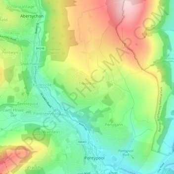
Name: Trevethin topographic map, elevation, terrain.
Location: Trevethin, Pontypool, Torfaen, Wales, United Kingdom (51.69860 -3.05881 51.73134 -3.02111)
Average elevation: 748 ft
Minimum elevation: 344 ft
Maximum elevation: 1,339 ft
Thank you for supporting this site ❤️
Make a donation
Make a donation
Gear up for your next adventure:
As an Amazon Associate, this site earns from qualifying purchases at no extra cost to you.