
Make a donation
Gear up for your next adventure:
As an Amazon Associate, this site earns from qualifying purchases at no extra cost to you.
Round Lake topographic map
Click on the map to display elevation.
Make a donation
Gear up for your next adventure:
As an Amazon Associate, this site earns from qualifying purchases at no extra cost to you.
About this map
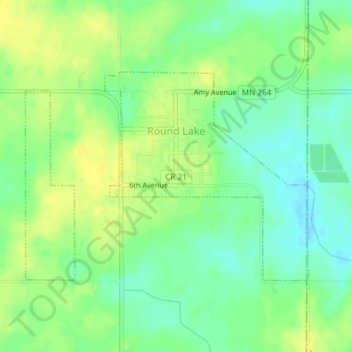
Name: Round Lake topographic map, elevation, terrain.
Location: Round Lake, Nobles County, Minnesota, 56167, United States (43.52902 -95.48431 43.54503 -95.45448)
Average elevation: 1,549 ft
Minimum elevation: 1,512 ft
Maximum elevation: 1,578 ft
Nobles County trails, hiking, mountain biking, running and outdoor activities
Make a donation
Gear up for your next adventure:
As an Amazon Associate, this site earns from qualifying purchases at no extra cost to you.
Other topographic maps
Click on a map to view its topography, its elevation and its terrain.
Sungold Heights Mobile Home Park
United States > Minnesota > Nobles County > Worthington
Average elevation: 1,581 ft