Geolocate

Joe Neets topographic map

Click on the map to display elevation.

About this map

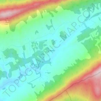
Name: Joe Neets topographic map, elevation, terrain.

Location: Joe Neets, Tazewell County, Virginia, United States (37.06262 -81.49844 37.10262 -81.45844)

Average elevation: 3,159 ft

Minimum elevation: 2,690 ft

Maximum elevation: 4,213 ft

Tazewell County trails, hiking, mountain biking, running and outdoor activities

Other topographic maps

Click on a map to view its topography, its elevation and its terrain.

Abbs Valley

United States > Virginia > Tazewell County > Abbs Valley

Average elevation: 2,818 ft

Gratton

United States > Virginia > Tazewell County > Gratton

Average elevation: 3,146 ft

Cedar Bluff

United States > Virginia > Tazewell County

Average elevation: 2,208 ft

Abbs Valley

United States > Virginia > Tazewell County > Abbs Valley

Average elevation: 2,818 ft

Bluefield

United States > Virginia > Tazewell County

Average elevation: 2,785 ft

Cedar Bluff

United States > Virginia > Tazewell County

Average elevation: 2,208 ft

Gear up for your next adventure:

📚USA Hiking Guide Books - Top trail guides and map books
🏕️Tent Footprint - Protect your tent base from wear
🥘Titanium Cookware - Durable, featherlight pots and pans for backpacking
🔋Solar Power Banks - Keep your GPS and phone charged in remote wilderness areas
🧭Hiking Compass - Precision compass for reliable navigation in the wilderness

As an Amazon Associate, this site earns from qualifying purchases at no extra cost to you.