
Make a donation
Gear up for your next adventure:
As an Amazon Associate, this site earns from qualifying purchases at no extra cost to you.
Pesaro e Urbino topographic map
Click on the map to display elevation.
Make a donation
Gear up for your next adventure:
As an Amazon Associate, this site earns from qualifying purchases at no extra cost to you.
About this map
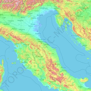
Name: Pesaro e Urbino topographic map, elevation, terrain.
Location: Pesaro e Urbino, Italy (41.13387 10.18676 46.33387 15.38676)
Average elevation: 912 ft
Minimum elevation: -20 ft
Maximum elevation: 11,335 ft
Make a donation
Gear up for your next adventure:
As an Amazon Associate, this site earns from qualifying purchases at no extra cost to you.
Other topographic maps
Click on a map to view its topography, its elevation and its terrain.
Campania
The climate is typically Mediterranean along the coast with warm, sunny and sultry summers and mild, rainy winters, whereas in the inner zones it is more continental, with lower temperatures in winter and warm summers. Snow is possible at higher elevations but rare at sea level. 51% of the total area is hilly,…
Average elevation: 1,060 ft
Make a donation
Gear up for your next adventure:
As an Amazon Associate, this site earns from qualifying purchases at no extra cost to you.
Piedmont
Piedmont has a typically temperate climate, which on the Alps becomes progressively temperate-cold and colder as it climbs to altitude. In areas located at low altitudes, winters are relatively cold but not very rainy and often sunny, with the possibility of snowfall, sometimes abundant. Snowfall, on the other…
Average elevation: 3,550 ft
Make a donation
Gear up for your next adventure:
As an Amazon Associate, this site earns from qualifying purchases at no extra cost to you.
Umbria
Umbria is bordered by Tuscany to the west and the north, Marche to the east and Lazio to the south. Partly hilly and mountainous, and partly flat and fertile owing to the valley of the Tiber, its topography includes part of the central Apennines, with the highest point in the region at Monte Vettore on the…
Average elevation: 1,709 ft
Make a donation
Gear up for your next adventure:
As an Amazon Associate, this site earns from qualifying purchases at no extra cost to you.
Sardinia
The climate of the island is variable from area to area, due to several factors including the extension in latitude and the elevation. It can be classified in two different macrobioclimates (Mediterranean pluviseasonal oceanic and Temperate oceanic), one macrobioclimatic variant (Submediterranean), and four…
Average elevation: 358 ft
Parch Natural Pöz-Odles - Naturpark Puez-Geisler - Parco Naturale Puez-Odle
Italy > Trentino-Alto Adige/Südtirol > South Tyrol
Average elevation: 6,175 ft