
Make a donation
Gear up for your next adventure:
As an Amazon Associate, this site earns from qualifying purchases at no extra cost to you.
Dillon topographic map
Click on the map to display elevation.
Make a donation
Gear up for your next adventure:
As an Amazon Associate, this site earns from qualifying purchases at no extra cost to you.
Dillon
Dillon is located at 45°12′57″N 112°38′3″W / 45.21583°N 112.63417°W / 45.21583; -112.63417 (45.215735, -112.634055), approximately 40 miles (64 km) east of the Continental Divide. It lies at an elevation of 5,102 feet (1,555 m).
Make a donation
Gear up for your next adventure:
As an Amazon Associate, this site earns from qualifying purchases at no extra cost to you.
About this map
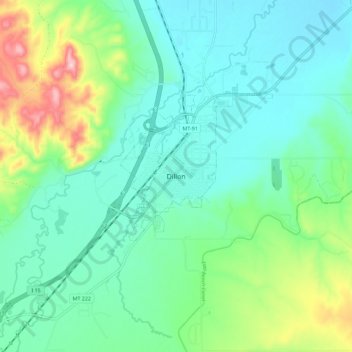
Name: Dillon topographic map, elevation, terrain.
Location: Dillon, Beaverhead County, Montana, United States (45.17412 -112.67461 45.25412 -112.59461)
Average elevation: 5,223 ft
Minimum elevation: 5,020 ft
Maximum elevation: 5,837 ft
Beaverhead County trails, hiking, mountain biking, running and outdoor activities
Make a donation
Gear up for your next adventure:
As an Amazon Associate, this site earns from qualifying purchases at no extra cost to you.