
Make a donation
Gear up for your next adventure:
As an Amazon Associate, this site earns from qualifying purchases at no extra cost to you.
Le Petit Carrey topographic map
Click on the map to display elevation.
Make a donation
Gear up for your next adventure:
As an Amazon Associate, this site earns from qualifying purchases at no extra cost to you.
About this map
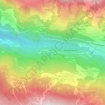
Name: Le Petit Carrey topographic map, elevation, terrain.
Average elevation: 3,960 ft
Minimum elevation: 2,156 ft
Maximum elevation: 5,879 ft
Make a donation
Gear up for your next adventure:
As an Amazon Associate, this site earns from qualifying purchases at no extra cost to you.
Other topographic maps
Click on a map to view its topography, its elevation and its terrain.
Saint-Bon-Tarentaise
France > Auvergne-Rhône-Alpes > Savoie > Courchevel
La commune de Saint-Bon-Tarentaise se situe dans le massif de la Vanoise dans les Alpes. Elle est à ce titre une commune de montagne dont l'altitude minimale s'établit à 700 mètres et dont le point culminant est le sommet de l'aiguille du Fruit à 3 051 m.
Average elevation: 6,365 ft