
Make a donation
Gear up for your next adventure:
As an Amazon Associate, this site earns from qualifying purchases at no extra cost to you.
Floridablanca topographic map
Click on the map to display elevation.
Make a donation
Gear up for your next adventure:
As an Amazon Associate, this site earns from qualifying purchases at no extra cost to you.
Floridablanca
Floridablanca is situated at an altitude of about 925 metres (3,035 ft) in the Eastern Ranges of the Colombian Andes, though locally the topography varies greatly. To the east of the city the higher mountains of the Andes rise above the city, thrusted upwards by the north–south-trending Bucaramanga-Santa Marta Fault, one of the major megaregional faults of Colombia. The area is dominated by the Bucaramanga Nest, the second-most seismically active region in the world. Because of the relatively low altitude, the city enjoys a very favorable climate all year round. Floridablanca's climate is classified as tropical. When compared with winter, the summers have much more rainfall. The climate is classified as Aw (tropical savanna climate) by the Köppen-Geiger system. The average annual temperature is 23.6 °C (74.5 °F) in Floridablanca. The rainfall averages 1,055 millimetres (41.5 in) per year.
Make a donation
Gear up for your next adventure:
As an Amazon Associate, this site earns from qualifying purchases at no extra cost to you.
About this map
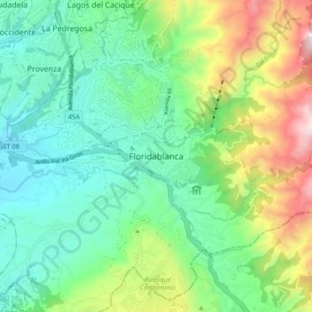
Name: Floridablanca topographic map, elevation, terrain.
Location: Floridablanca, Metropolitana, Santander, 681004, Colombia (7.02254 -73.12582 7.10254 -73.04582)
Average elevation: 3,579 ft
Minimum elevation: 2,470 ft
Maximum elevation: 6,165 ft
Make a donation
Gear up for your next adventure:
As an Amazon Associate, this site earns from qualifying purchases at no extra cost to you.