
Sandy topographic map
Click on the map to display elevation.
About this map
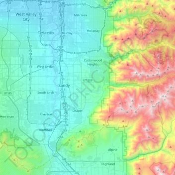
Name: Sandy topographic map, elevation, terrain.
Location: Sandy, Salt Lake County, Utah, 84094, United States (40.40649 -111.99890 40.72649 -111.67890)
Average elevation: 5,994 ft
Minimum elevation: 4,236 ft
Maximum elevation: 11,411 ft
Salt Lake County trails, hiking, mountain biking, running and outdoor activities
Other topographic maps
Click on a map to view its topography, its elevation and its terrain.
Granite Park
United States > Utah > Salt Lake County > Sandy > Granite Crest
Average elevation: 5,033 ft