Geolocate

Calcinelli topographic map

Click on the map to display elevation.

About this map
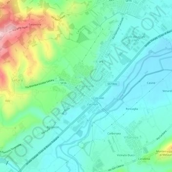
Name: Calcinelli topographic map, elevation, terrain.

Location: Calcinelli, Colli al Metauro, Pesaro e Urbino, Marche, 61036, Italia (43.73223 12.89953 43.77223 12.93953)

Average elevation: 299 ft

Minimum elevation: 102 ft

Maximum elevation: 876 ft

Other topographic maps

Click on a map to view its topography, its elevation and its terrain.

Montelabbate

Italia > Marche > Pesaro e Urbino

L'altitudine è compresa tra i 50 e i 300 m s.l.m.

Average elevation: 430 ft

Tavullia

Italia > Marche > Pesaro e Urbino

Average elevation: 312 ft

Monte Cerignone

Italia > Marche > Pesaro e Urbino

Average elevation: 1,883 ft

Mombaroccio

Italia > Marche > Pesaro e Urbino

Average elevation: 591 ft

Lunano

Italia > Marche > Pesaro e Urbino

Average elevation: 1,309 ft

Petriano

Italia > Marche > Pesaro e Urbino

Average elevation: 722 ft

Mondavio

Italia > Marche > Pesaro e Urbino

Average elevation: 548 ft

Gear up for your next adventure:

📻Weather Alert Radios - Stay informed of storm risks while off-the-grid
🪶Survival Guide Book - Expert advice for emergency preparedness
🧭Pro Hiking Compasses - High-accuracy liquid-filled compasses for topographic orientation
🪶Camping Sleeping Pad - Comfortable sleeping pad for backpacking
🌧️Backpack Rain Cover - Keep gear dry in wet weather

As an Amazon Associate, this site earns from qualifying purchases at no extra cost to you.