
Thank you for supporting this site ❤️
Make a donation
Make a donation
Gear up for your next adventure:
As an Amazon Associate, this site earns from qualifying purchases at no extra cost to you.
Bayanag topographic map
Click on the map to display elevation.
Thank you for supporting this site ❤️
Make a donation
Make a donation
Gear up for your next adventure:
As an Amazon Associate, this site earns from qualifying purchases at no extra cost to you.
About this map
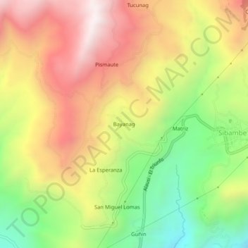
Name: Bayanag topographic map, elevation, terrain.
Location: Bayanag, Sibambe, Alausí, Chimborazo, 060259, Ecuador (-2.24396 -78.92831 -2.20396 -78.88831)
Average elevation: 8,576 ft
Minimum elevation: 6,762 ft
Maximum elevation: 10,322 ft
Thank you for supporting this site ❤️
Make a donation
Make a donation
Gear up for your next adventure:
As an Amazon Associate, this site earns from qualifying purchases at no extra cost to you.