
Make a donation
Gear up for your next adventure:
As an Amazon Associate, this site earns from qualifying purchases at no extra cost to you.
Thaba Nchu 1 topographic map
Click on the map to display elevation.
Make a donation
Gear up for your next adventure:
As an Amazon Associate, this site earns from qualifying purchases at no extra cost to you.
About this map
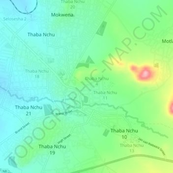
Name: Thaba Nchu 1 topographic map, elevation, terrain.
Average elevation: 5,010 ft
Minimum elevation: 4,872 ft
Maximum elevation: 5,374 ft
Make a donation
Gear up for your next adventure:
As an Amazon Associate, this site earns from qualifying purchases at no extra cost to you.
Other topographic maps
Click on a map to view its topography, its elevation and its terrain.
Mangaung Ward 47
South Africa > Free State > Mangaung Metropolitan Municipality
Average elevation: 4,521 ft
Mangaung Ward 38
South Africa > Free State > Mangaung Metropolitan Municipality
Average elevation: 4,997 ft
Bloemspruit
South Africa > Free State > Mangaung Metropolitan Municipality
Average elevation: 4,380 ft
Naval Hill Park
South Africa > Free State > Mangaung Metropolitan Municipality > Bloemfontein
Average elevation: 4,715 ft
Make a donation
Gear up for your next adventure:
As an Amazon Associate, this site earns from qualifying purchases at no extra cost to you.
Krugersdrift
South Africa > Free State > Mangaung Metropolitan Municipality
Average elevation: 4,094 ft