
Thank you for supporting this site ❤️
Make a donation
Make a donation
Gear up for your next adventure:
As an Amazon Associate, this site earns from qualifying purchases at no extra cost to you.
Walmara topographic map
Click on the map to display elevation.
Thank you for supporting this site ❤️
Make a donation
Make a donation
Gear up for your next adventure:
As an Amazon Associate, this site earns from qualifying purchases at no extra cost to you.
About this map
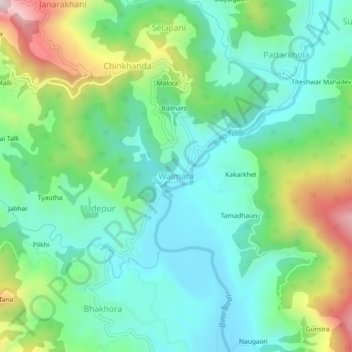
Name: Walmara topographic map, elevation, terrain.
Location: Walmara, Syalde, Almora District, Uttarakhand, 263661, India (29.83397 79.18319 29.87397 79.22319)
Average elevation: 3,422 ft
Minimum elevation: 2,854 ft
Maximum elevation: 4,806 ft
Thank you for supporting this site ❤️
Make a donation
Make a donation
Gear up for your next adventure:
As an Amazon Associate, this site earns from qualifying purchases at no extra cost to you.