
Make a donation
Gear up for your next adventure:
As an Amazon Associate, this site earns from qualifying purchases at no extra cost to you.
Montes da Senhora topographic map
Click on the map to display elevation.
Make a donation
Gear up for your next adventure:
As an Amazon Associate, this site earns from qualifying purchases at no extra cost to you.
About this map
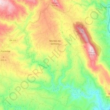
Name: Montes da Senhora topographic map, elevation, terrain.
Location: Montes da Senhora, Proença-a-Nova, Castelo Branco, Portugal (39.73489 -7.83203 39.80391 -7.73967)
Average elevation: 1,158 ft
Minimum elevation: 430 ft
Maximum elevation: 2,001 ft
Make a donation
Gear up for your next adventure:
As an Amazon Associate, this site earns from qualifying purchases at no extra cost to you.
Other topographic maps
Click on a map to view its topography, its elevation and its terrain.
Make a donation
Gear up for your next adventure:
As an Amazon Associate, this site earns from qualifying purchases at no extra cost to you.
Lameira Martins
Portugal > Castelo Branco > Proença-a-Nova > São Pedro do Esteval
Average elevation: 820 ft
Make a donation
Gear up for your next adventure:
As an Amazon Associate, this site earns from qualifying purchases at no extra cost to you.