
Suches topographic map
Click on the map to display elevation.
About this map
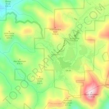
Name: Suches topographic map, elevation, terrain.
Location: Suches, Union County, Georgia, United States (34.66898 -84.04214 34.70898 -84.00214)
Average elevation: 2,858 ft
Minimum elevation: 2,198 ft
Maximum elevation: 3,691 ft
Union County trails, hiking, mountain biking, running and outdoor activities
Other topographic maps
Click on a map to view its topography, its elevation and its terrain.
Blairsville
United States > Georgia > Union County
Blairsville, Georgia, is situated in the picturesque Appalachian Mountains, characterized by a varied topography that includes rolling hills, lush valleys, and prominent mountain ridges. The elevation of the town itself is approximately 1,800 feet, providing breathtaking views of the surrounding landscape. The…
Average elevation: 1,926 ft