
Thank you for supporting this site ❤️
Make a donation
Make a donation
Gear up for your next adventure:
As an Amazon Associate, this site earns from qualifying purchases at no extra cost to you.
Udalaitz topographic map
Click on the map to display elevation.
Thank you for supporting this site ❤️
Make a donation
Make a donation
Gear up for your next adventure:
As an Amazon Associate, this site earns from qualifying purchases at no extra cost to you.
About this map
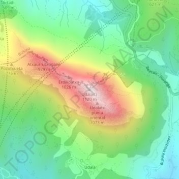
Name: Udalaitz topographic map, elevation, terrain.
Location: Udalaitz, Mondragón, Guipúzcoa, País Vasco, 20500, España (43.08997 -2.51374 43.09007 -2.51364)
Average elevation: 1,844 ft
Minimum elevation: 833 ft
Maximum elevation: 3,602 ft
Thank you for supporting this site ❤️
Make a donation
Make a donation
Gear up for your next adventure:
As an Amazon Associate, this site earns from qualifying purchases at no extra cost to you.