Geolocate

Fidalgo Island topographic map

Click on the map to display elevation.

About this map

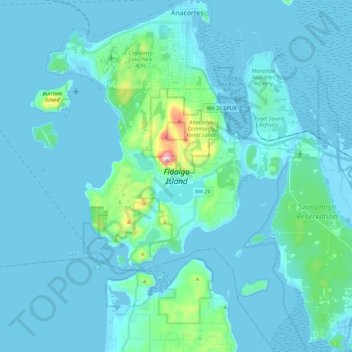
Name: Fidalgo Island topographic map, elevation, terrain.

Location: Fidalgo Island, Anacortes, Skagit County, Washington, United States (48.37107 -122.70300 48.52219 -122.49783)

Average elevation: 105 ft

Minimum elevation: -13 ft

Maximum elevation: 1,250 ft

Skagit County trails, hiking, mountain biking, running and outdoor activities

Other topographic maps

Click on a map to view its topography, its elevation and its terrain.

Mount Erie

United States > Washington > Skagit County > Anacortes

Average elevation: 420 ft

Gear up for your next adventure:

🗃️Trail First Aid Kit - Essential kit for outdoor injuries and emergencies
🎒Waterproof Dry Bags - Keep your electronics and maps dry inside your pack
🗻Climbing Gear Basics - Essential gear for beginner climbers
🌎3D Topographic Globes - Raised relief globes for a tactile understanding of geography
🛡️Bear Spray Outdoor - Protection in bear country hikes

As an Amazon Associate, this site earns from qualifying purchases at no extra cost to you.