Geolocate

Bierstadt topographic map

Click on the map to display elevation.

About this map

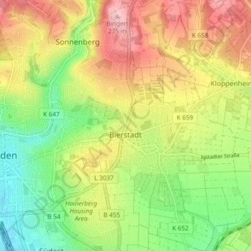
Name: Bierstadt topographic map, elevation, terrain.

Location: Bierstadt, Wiesbaden, Hesse, 65191, Germany (50.06535 8.26169 50.10882 8.31039)

Average elevation: 627 ft

Minimum elevation: 351 ft

Maximum elevation: 948 ft

Gear up for your next adventure:

Solar GPS Watches - Advanced multisport watches with built-in topographic maps
🛡️Insect Repellent - Protection against bugs during outdoor activities
🔌Solar Panel Charger - Charge gear sustainably outdoors
🔌USB Car Charger - Car charger for on‑the‑go power needs
🧭Hiking Compass - Precision compass for reliable navigation in the wilderness

As an Amazon Associate, this site earns from qualifying purchases at no extra cost to you.