Geolocate

Wervik topographic map

Click on the map to display elevation.

About this map
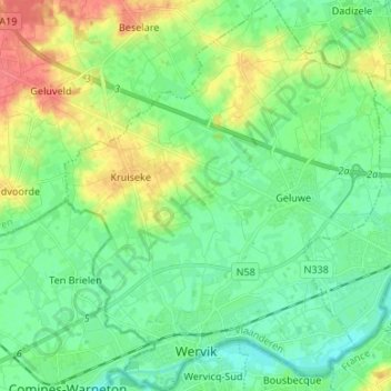
Name: Wervik topographic map, elevation, terrain.

Location: Wervik, Ieper, West Flanders, Flanders, 8940, Belgium (50.76973 2.99853 50.85402 3.10738)

Average elevation: 82 ft

Minimum elevation: 26 ft

Maximum elevation: 194 ft

Other topographic maps

Click on a map to view its topography, its elevation and its terrain.
Polderhoek

Belgium > West Flanders > Ieper > Zonnebeke > Geluveld > Poezelhoek

Average elevation: 148 ft
Kemmelberg

Belgium > West Flanders > Ieper > Heuvelland

Average elevation: 223 ft

Rodeberg

Belgium > West Flanders > Ieper > Heuvelland

Average elevation: 269 ft

Gear up for your next adventure:

🌡️Handheld Weather Meters - Measure wind, temp, and pressure for safe mountain travel
🧣Merino Neck Gaiters - Multi-functional headwear for wind and sun protection
🥄Camping Utensil Set - Lightweight utensils for outdoor meals
🗃️Trail First Aid Kit - Essential kit for outdoor injuries and emergencies
🥾Men's Hiking Boots - Durable, waterproof footwear for rugged terrain and steep inclines

As an Amazon Associate, this site earns from qualifying purchases at no extra cost to you.