
Make a donation
Gear up for your next adventure:
As an Amazon Associate, this site earns from qualifying purchases at no extra cost to you.
Piamonte topographic map
Click on the map to display elevation.
Make a donation
Gear up for your next adventure:
As an Amazon Associate, this site earns from qualifying purchases at no extra cost to you.
Piamonte
Altitud de la cabecera municipal (metros sobre el nivel del mar): 310 m s. n. m.
Make a donation
Gear up for your next adventure:
As an Amazon Associate, this site earns from qualifying purchases at no extra cost to you.
About this map
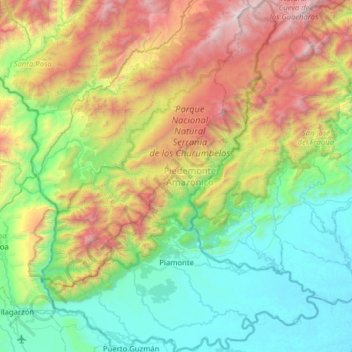
Name: Piamonte topographic map, elevation, terrain.
Location: Piamonte, Piedemonte Amazónico, Cauca, RAP Pacífico, Colombia (0.95857 -76.56639 1.58722 -76.07460)
Average elevation: 3,484 ft
Minimum elevation: 715 ft
Maximum elevation: 9,862 ft
Make a donation
Gear up for your next adventure:
As an Amazon Associate, this site earns from qualifying purchases at no extra cost to you.
Other topographic maps
Click on a map to view its topography, its elevation and its terrain.