
Kuningan topographic map
Click on the map to display elevation.
About this map
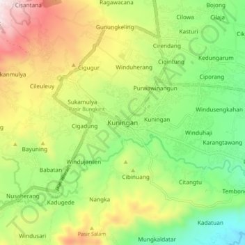
Name: Kuningan topographic map, elevation, terrain.
Location: Kuningan, West Java, Java, 45511, Indonesia (-7.02215 108.43680 -6.94215 108.51680)
Average elevation: 1,844 ft
Minimum elevation: 610 ft
Maximum elevation: 3,655 ft
Other topographic maps
Click on a map to view its topography, its elevation and its terrain.
Gunung Ciremai National Park
Indonesia > West Java > Kuningan > Padabeunghar
Average elevation: 2,881 ft