Geolocate

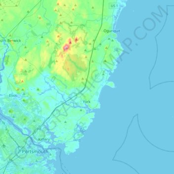
York topographic map

Click on the map to display elevation.

York

According to the United States Census Bureau, the town has a total area of 131.78 square miles (341.31 km2), of which 54.67 square miles (141.59 km2) is land and 77.11 square miles (199.71 km2) is water. The York watershed drains into the York River. The highest point in town is Mount Agamenticus, with an elevation of 692 feet (211 meters) above sea level. A road travels to the summit, where miles of hiking, biking and horse-riding trails are available. The lowest point in town is sea level, along the coastline with the Atlantic Ocean. York lies about 44 miles (71 km) south of Portland, 98 miles (158 km) south of Augusta, and 65 miles (105 km) north of Boston.

Wikipedia (CC-BY-SA 3.0)

About this map

Name: York topographic map, elevation, terrain.

Location: York, York County, Maine, United States (43.07006 -70.75739 43.26087 -70.40476)

Average elevation: 59 ft

Minimum elevation: -20 ft

Maximum elevation: 676 ft

York County trails, hiking, mountain biking, running and outdoor activities

Other topographic maps

Click on a map to view its topography, its elevation and its terrain.

Boon Island

United States > Maine > York County > York

Average elevation: 0 ft

Lake Sherburne

United States > Maine > York County > Waterboro

Average elevation: 466 ft

Wells Beach

United States > Maine > York County > Wells

Average elevation: 3 ft

Jamaica Island

United States > Maine > York County > Kittery

Average elevation: 102 ft

Parsons Beach

United States > Maine > York County > Kennebunk

Average elevation: 10 ft

Crescent Beach

United States > Maine > York County > Kittery

Average elevation: 16 ft

Mount Agamenticus

United States > Maine > York County > York

Average elevation: 302 ft

Boon Island

United States > Maine > York County > York

Average elevation: 0 ft

Ogunquit Beach

United States > Maine > York County > Ogunquit

Average elevation: 36 ft

Holdsworth Park

United States > Maine > York County > Sanford

Average elevation: 427 ft

Gear up for your next adventure:

🚪Portable Camp Chair - Foldable chair for comfort at camp
🎒Waterproof Dry Bags - Keep your electronics and maps dry inside your pack
🪵Folding Camp Saw - Compact saw for wood and campsite work
🗺️NatGeo Topo Maps - High-quality waterproof printed topographic maps of US Parks
🦟Ultrasonic Repellers - Create a bug-free zone at your camp or rest stop

As an Amazon Associate, this site earns from qualifying purchases at no extra cost to you.