Geolocate

Mount Agamenticus topographic map

Click on the map to display elevation.

About this map

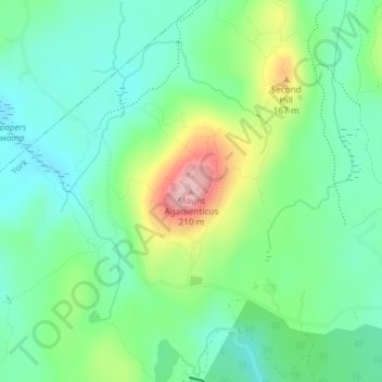
Name: Mount Agamenticus topographic map, elevation, terrain.

Location: Mount Agamenticus, York, York County, Maine, United States (43.22337 -70.69223 43.22347 -70.69213)

Average elevation: 302 ft

Minimum elevation: 135 ft

Maximum elevation: 682 ft

Other topographic maps

Click on a map to view its topography, its elevation and its terrain.

Boon Island

United States > Maine > York County > York

Average elevation: 0 ft

Cape Neddick

United States > Maine > York County > York > Cape Neddick

Average elevation: 43 ft

Boon Island

United States > Maine > York County > York

Average elevation: 0 ft

Cape Neddick

United States > Maine > York County > York > Cape Neddick

Average elevation: 43 ft

York River

United States > Maine > York County > York

Average elevation: 102 ft

Gear up for your next adventure:

🔌Solar Panel Charger - Charge gear sustainably outdoors
🪶Multi‑Purpose Knife - Useful blade for camp and trail
🧭Compass with Lanyard - Easy‑carry compass for navigation
💧Water Purification System - Clean water on the trail with reliable purifiers
👓Polarized Sunglasses - Outdoor sunglasses for glare reduction

As an Amazon Associate, this site earns from qualifying purchases at no extra cost to you.