Geolocate

Reiskirchen topographic map

Click on the map to display elevation.

About this map

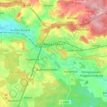
Name: Reiskirchen topographic map, elevation, terrain.

Location: Reiskirchen, Landkreis Gießen, Hesse, 35447, Germany (50.54742 8.80217 50.63180 8.92490)

Average elevation: 801 ft

Minimum elevation: 584 ft

Maximum elevation: 1,132 ft

Other topographic maps

Click on a map to view its topography, its elevation and its terrain.

Spitze

Germany > Hesse > Landkreis Gießen > Annerod

Average elevation: 817 ft

Hungen

Germany > Hesse > Landkreis Gießen

Average elevation: 525 ft

Lich

Germany > Hesse > Landkreis Gießen > Lich > Lich

Average elevation: 656 ft

Gear up for your next adventure:

🧭GPS Watch Accessories - Bands and chargers for GPS watches
💧Water Filtration Bottles - Safely drink from streams and lakes while exploring
📡GPS Antenna Upgrade - Enhance GPS reception in remote terrain
🥾Hiking Shoes - Durable and comfortable shoes for trail hiking
🎒Trekking Poles - Sturdy poles for balance and stability on rough terrain

As an Amazon Associate, this site earns from qualifying purchases at no extra cost to you.