
Swalcliffe topographic map
Click on the map to display elevation.
About this map
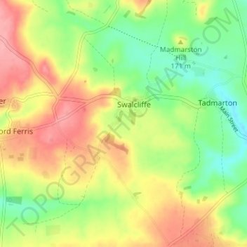
Name: Swalcliffe topographic map, elevation, terrain.
Average elevation: 535 ft
Minimum elevation: 384 ft
Maximum elevation: 699 ft
Other topographic maps
Click on a map to view its topography, its elevation and its terrain.
Roman Meadow Banbury Country Park
United Kingdom > England > Oxfordshire > Cherwell District > Little Bourton
Average elevation: 338 ft
Williamscot
United Kingdom > England > Oxfordshire > Cherwell District > Cropredy > Williamscot
Average elevation: 387 ft
Stoke Lyne
United Kingdom > England > Oxfordshire > Cherwell District > Stoke Lyne
Average elevation: 381 ft
Shipton-on-Cherwell
United Kingdom > England > Oxfordshire > Cherwell District
Average elevation: 256 ft
Hampton Gay
United Kingdom > England > Oxfordshire > Cherwell District > Shipton-on-Cherwell
Average elevation: 246 ft
Little Chesterton
United Kingdom > England > Oxfordshire > Cherwell District > Wendlebury
Average elevation: 236 ft
Nethercote
United Kingdom > England > Oxfordshire > Cherwell District > Banbury
Average elevation: 364 ft
Down End
United Kingdom > England > Oxfordshire > Cherwell District > Hook Norton
Average elevation: 568 ft
Nethercote
United Kingdom > England > Oxfordshire > Cherwell District > Banbury
Average elevation: 364 ft