Geolocate

Cuccurano topographic map

Click on the map to display elevation.

About this map

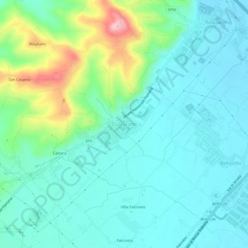
Name: Cuccurano topographic map, elevation, terrain.

Location: Cuccurano, Fano, Pesaro e Urbino, Marche, 61032, Italia (43.78237 12.95540 43.82237 12.99540)

Average elevation: 220 ft

Minimum elevation: 66 ft

Maximum elevation: 745 ft

Gear up for your next adventure:

🏕️Tent Footprint - Protect your tent base from wear
🪓Survival Multi‑Tool - Versatile tool for camp and trail tasks
❄️Traction Cleats - Prevent slips on icy trails during winter hikes
🕶️GPS Smartphone Mount - Secure mount for phone navigation
🧷Carabiner Set - Durable clips for gear attachment

As an Amazon Associate, this site earns from qualifying purchases at no extra cost to you.