Geolocate

Haynes topographic map

Click on the map to display elevation.

About this map

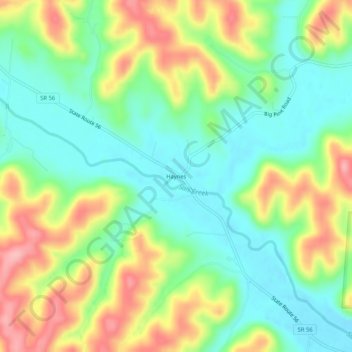
Name: Haynes topographic map, elevation, terrain.

Location: Haynes, Hocking County, Ohio, United States (39.41479 -82.69906 39.45479 -82.65906)

Average elevation: 837 ft

Minimum elevation: 669 ft

Maximum elevation: 1,099 ft

Hocking County trails, hiking, mountain biking, running and outdoor activities

Other topographic maps

Click on a map to view its topography, its elevation and its terrain.

Murray City

United States > Ohio > Hocking County

Average elevation: 843 ft

Rose Lake

United States > Ohio > Hocking County

Average elevation: 968 ft

Logan

United States > Ohio > Hocking County

Average elevation: 833 ft

Rose Lake Dam

United States > Ohio > Hocking County

Average elevation: 974 ft

Gear up for your next adventure:

🪶Wildlife Field Guides - Learn animal tracking and species ID
🪶Thermal Camp Blanket - Extra warmth for cold nights
🎒Trail Energy Bars - High‑calorie bars for hiking energy
👓Polarized Sunglasses - Outdoor sunglasses for glare reduction
📶Vehicle Signal Boosters - Improve reception in rural areas while driving to trailheads

As an Amazon Associate, this site earns from qualifying purchases at no extra cost to you.