
Make a donation
Gear up for your next adventure:
As an Amazon Associate, this site earns from qualifying purchases at no extra cost to you.
Uzwil topographic map
Click on the map to display elevation.
Make a donation
Gear up for your next adventure:
As an Amazon Associate, this site earns from qualifying purchases at no extra cost to you.
Uzwil
Der Weiler mit 61 Einwohnern befindet sich auf einer Anhöhe zwischen Uzwil und der Strasse Oberuzwil–Flawil. In der Nähe befindet sich der Stolzenbergweiher. Von Uzwil oder Niederuzwil aus ist die Pappel-Allee, welche sich vor Stolzenberg oberhalb der Bahnlinie befindet, gut sichtbar.
Make a donation
Gear up for your next adventure:
As an Amazon Associate, this site earns from qualifying purchases at no extra cost to you.
About this map
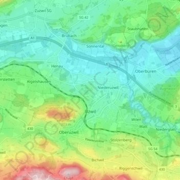
Name: Uzwil topographic map, elevation, terrain.
Location: Uzwil, Wahlkreis Wil, St. Gallen, Schweiz (47.42405 9.06608 47.46445 9.15653)
Average elevation: 1,873 ft
Minimum elevation: 1,578 ft
Maximum elevation: 2,621 ft
Make a donation
Gear up for your next adventure:
As an Amazon Associate, this site earns from qualifying purchases at no extra cost to you.