Geolocate

Reydon topographic map

Click on the map to display elevation.

About this map

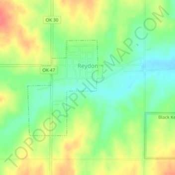
Name: Reydon topographic map, elevation, terrain.

Location: Reydon, Roger Mills County, Oklahoma, 73660, United States (35.64287 -99.93044 35.65759 -99.91616)

Average elevation: 2,323 ft

Minimum elevation: 2,238 ft

Maximum elevation: 2,425 ft

Roger Mills County trails, hiking, mountain biking, running and outdoor activities

Other topographic maps

Click on a map to view its topography, its elevation and its terrain.

Carpenter

United States > Oklahoma > Roger Mills County

Average elevation: 1,959 ft

Berlin

United States > Oklahoma > Roger Mills County

Average elevation: 2,116 ft

Dempsey

United States > Oklahoma > Roger Mills County

Average elevation: 2,405 ft

Gear up for your next adventure:

🪶Multi‑Purpose Knife - Useful blade for camp and trail
🪶Paracord Bracelet - Survival bracelet with built‑in tools
🛌Ultralight Sleeping Bags - Compact down bags for cold nights in the wilderness
🕶️GPS Smartphone Mount - Secure mount for phone navigation
🕶️Glacier Sunglasses - Side shields to protect eyes from high-altitude snow glare

As an Amazon Associate, this site earns from qualifying purchases at no extra cost to you.