Geolocate

Scilla topographic map

Click on the map to display elevation.

About this map

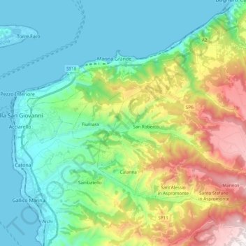
Name: Scilla topographic map, elevation, terrain.

Location: Scilla, Reggio Calabria, Calabria, 89058, Italy (38.15791 15.68703 38.26835 15.87713)

Average elevation: 1,155 ft

Minimum elevation: -3 ft

Maximum elevation: 4,167 ft

Other topographic maps

Click on a map to view its topography, its elevation and its terrain.

Saline Joniche

Italy > Calabria > Reggio Calabria

Average elevation: 190 ft

Monasterace Marina

Italy > Calabria > Reggio Calabria

Average elevation: 62 ft

Gambarie

Italy > Calabria > Reggio Calabria

Average elevation: 4,281 ft

Gear up for your next adventure:

🥾Hiking Shoes - Durable and comfortable shoes for trail hiking
🌐World Map Poster - Decorative world maps with topographic info
🛡️Bear Spray Outdoor - Protection in bear country hikes
🧥Men's Rain Shells - Premium waterproof and breathable jackets for mountain weather
🌧️Backpack Rain Cover - Keep gear dry in wet weather

As an Amazon Associate, this site earns from qualifying purchases at no extra cost to you.