Geolocate

Bray topographic map

Click on the map to display elevation.

About this map

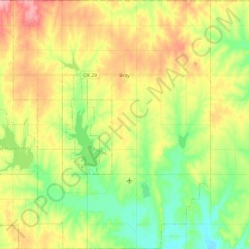
Name: Bray topographic map, elevation, terrain.

Location: Bray, Stephens County, Oklahoma, United States (34.53599 -97.89683 34.68162 -97.75622)

Average elevation: 1,207 ft

Minimum elevation: 1,040 ft

Maximum elevation: 1,421 ft

Stephens County trails, hiking, mountain biking, running and outdoor activities

Other topographic maps

Click on a map to view its topography, its elevation and its terrain.

Countyline

United States > Oklahoma > Stephens County

Average elevation: 1,017 ft

Gear up for your next adventure:

🥘Titanium Cookware - Durable, featherlight pots and pans for backpacking
🪵Folding Camp Saw - Compact saw for wood and campsite work
🚗GPS Dash Cams - Record your scenic drives through mountain passes and canyons
🧭Pro Hiking Compasses - High-accuracy liquid-filled compasses for topographic orientation
🎒Trekking Poles - Sturdy poles for balance and stability on rough terrain

As an Amazon Associate, this site earns from qualifying purchases at no extra cost to you.