
Make a donation
Gear up for your next adventure:
As an Amazon Associate, this site earns from qualifying purchases at no extra cost to you.
Malinche topographic map
Click on the map to display elevation.
Make a donation
Gear up for your next adventure:
As an Amazon Associate, this site earns from qualifying purchases at no extra cost to you.
Malinche
On lower slopes are farmlands which grow mostly field "dent" corn and forests which transition from alders and various types of oak to Montezuma pines and sacred firs with increasing elevation. The upper slopes are zacatonal. The summit is covered by snow part of the year and is considered to be the coldest location in Tlaxcala. On the lower slopes the climate is mild year round, but rainy during the summer months. The soils consist of crushed volcanic rock and sand with an underlying layer of clay and sand called tepetate at an average depth of about a meter. The dark and porous forest soils were formed from volcanic ash. From La Malinche streams flow in all directions forming small gorges in places which fill and run rapidly when torrential rains occur. At the base of the mountain emerge many springs, some of drinkable water, and others of thermal water heated in the volcano's interior.
Make a donation
Gear up for your next adventure:
As an Amazon Associate, this site earns from qualifying purchases at no extra cost to you.
About this map
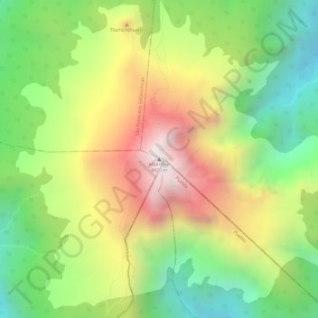
Name: Malinche topographic map, elevation, terrain.
Location: Malinche, Teolocholco, Tlaxcala, Mexico (19.23091 -98.03221 19.23101 -98.03211)
Average elevation: 12,831 ft
Minimum elevation: 11,355 ft
Maximum elevation: 14,475 ft
Make a donation
Gear up for your next adventure:
As an Amazon Associate, this site earns from qualifying purchases at no extra cost to you.