Geolocate

Llangybi topographic map

Click on the map to display elevation.

About this map

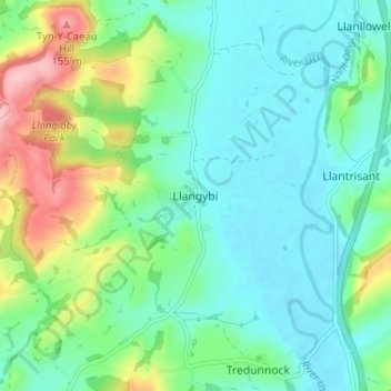
Name: Llangybi topographic map, elevation, terrain.

Location: Llangybi, Monmouthshire, Wales, NP15 1PJ, United Kingdom (51.64572 -2.92813 51.68572 -2.88813)

Average elevation: 161 ft

Minimum elevation: 20 ft

Maximum elevation: 551 ft

Other topographic maps

Click on a map to view its topography, its elevation and its terrain.

Wye Valley

United Kingdom > Wales > Monmouthshire

Average elevation: 548 ft

Chepstow Castle

United Kingdom > Wales > Monmouthshire > Chepstow

Average elevation: 174 ft

Penallt

United Kingdom > Wales > Monmouthshire

Average elevation: 571 ft

Crucorney

United Kingdom > Wales > Monmouthshire

Average elevation: 974 ft

Blorenge

United Kingdom > Wales > Monmouthshire > Govilon

Average elevation: 1,293 ft

River Monnow

United Kingdom > Wales > Monmouthshire

Average elevation: 564 ft

Llanbadoc

United Kingdom > Wales > Monmouthshire

Average elevation: 256 ft

Raglan Castle

United Kingdom > Wales > Monmouthshire > Raglan

Average elevation: 194 ft

River Monnow

United Kingdom > Wales > Monmouthshire

Average elevation: 564 ft

Gear up for your next adventure:

❄️Traction Cleats - Prevent slips on icy trails during winter hikes
Solar GPS Watches - Advanced multisport watches with built-in topographic maps
🔥Camping Stove - Portable stove for camping and backcountry cooking
🎒Outdoor Daypacks - Lightweight backpacks designed for carrying maps and essential gear
📱Heavy-Duty Phone Cases - Drop-proof and waterproof protection for outdoor navigation

As an Amazon Associate, this site earns from qualifying purchases at no extra cost to you.