Geolocate

Cedarville topographic map

Click on the map to display elevation.

About this map

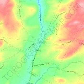
Name: Cedarville topographic map, elevation, terrain.

Location: Cedarville, Town of Columbia, Herkimer County, New York, United States (42.91063 -75.13266 42.95063 -75.09266)

Average elevation: 1,348 ft

Minimum elevation: 1,119 ft

Maximum elevation: 1,578 ft

Herkimer County trails, hiking, mountain biking, running and outdoor activities

Other topographic maps

Click on a map to view its topography, its elevation and its terrain.

Town of Russia

United States > New York > Herkimer County

Average elevation: 1,234 ft

Town of Warren

United States > New York > Herkimer County

Average elevation: 1,499 ft

Windfall Pond

United States > New York > Herkimer County

Average elevation: 2,024 ft

Town of Salisbury

United States > New York > Herkimer County

Average elevation: 1,512 ft

South Ilion

United States > New York > Herkimer County

Average elevation: 784 ft

Town of Danube

United States > New York > Herkimer County

Average elevation: 761 ft

Town of Webb

United States > New York > Herkimer County

Average elevation: 1,722 ft

Twitchell Lake

United States > New York > Herkimer County

Average elevation: 2,136 ft

Weaver Lake

United States > New York > Herkimer County > Warren

Average elevation: 1,414 ft

Lake Tekeni

United States > New York > Herkimer County

Average elevation: 1,827 ft

Town of Litchfield

United States > New York > Herkimer County

Average elevation: 1,329 ft

Town of Newport

United States > New York > Herkimer County

Average elevation: 1,027 ft

Herkimer

United States > New York > Herkimer County > Herkimer

In 1722, in response to a request by the German Palatine leaders Joseph Petrie and Conrad Rickert, Governor William Burnet granted the Palatines a lease to purchase land from the Mohawk Nation in the vicinity of the confluence of West Canada Creek and the Mohawk River. After a survey of the land was completed…

Average elevation: 505 ft

Moss Lake

United States > New York > Herkimer County

Average elevation: 1,903 ft

Town of Ohio

United States > New York > Herkimer County

Average elevation: 1,699 ft

Town of Columbia

United States > New York > Herkimer County

Average elevation: 1,414 ft

Gear up for your next adventure:

🗺️Topographic Maps - Detailed topo maps for hiking, exploring and outdoor navigation
🏕️Family Camping Gear - Essentials for group camping trips
📶Vehicle Signal Boosters - Improve reception in rural areas while driving to trailheads
📚Navigation Handbooks - Master the art of reading topographic maps and using a compass
🏫Relief Map Kits - Hands-on tools for teaching landforms and elevation

As an Amazon Associate, this site earns from qualifying purchases at no extra cost to you.