
Make a donation
Gear up for your next adventure:
As an Amazon Associate, this site earns from qualifying purchases at no extra cost to you.
Gustav-Comberg-Park topographic map
Click on the map to display elevation.
Make a donation
Gear up for your next adventure:
As an Amazon Associate, this site earns from qualifying purchases at no extra cost to you.
About this map
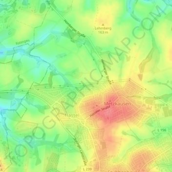
Name: Gustav-Comberg-Park topographic map, elevation, terrain.
Average elevation: 502 ft
Minimum elevation: 387 ft
Maximum elevation: 614 ft
Make a donation
Gear up for your next adventure:
As an Amazon Associate, this site earns from qualifying purchases at no extra cost to you.
Other topographic maps
Click on a map to view its topography, its elevation and its terrain.
Obschwarzbach
Deutschland > Nordrhein-Westfalen > Kreis Mettmann > Mettmann
Obschwarzbach liegt im Niederbergischen Land, auf den Höhen der Mettmanner Lössterrassen, die bereits zum Rheinischen Schiefergebirge gehören. Der Ort ist überwiegend ländlich geprägt und besteht aus den beiden Teilen Niederschwarzbach und Obschwarzbach. Im Zentrum, unmittelbar an der L 422, befindet…
Average elevation: 525 ft