Geolocate

Alpuech topographic map

Click on the map to display elevation.

About this map

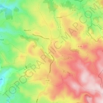
Name: Alpuech topographic map, elevation, terrain.

Location: Alpuech, Argences en Aubrac, Rodez, Aveyron, Occitanie, France métropolitaine, 12210, France (44.71272 2.82266 44.78015 2.93078)

Average elevation: 3,622 ft

Minimum elevation: 2,949 ft

Maximum elevation: 4,288 ft

Other topographic maps

Click on a map to view its topography, its elevation and its terrain.

Le Viala

France > Occitanie > Aveyron > Argences en Aubrac

Average elevation: 3,182 ft

Le Born

France > Occitanie > Aveyron > Argences en Aubrac

Average elevation: 3,127 ft

Les Clauzels

France > Occitanie > Aveyron > Argences en Aubrac

Average elevation: 3,094 ft

Le Cayrac

France > Occitanie > Aveyron > Argences en Aubrac

Average elevation: 3,074 ft

Le Batut

France > Occitanie > Aveyron > Argences en Aubrac

Average elevation: 2,838 ft

Gear up for your next adventure:

🥾Hiking Shoes - Durable and comfortable shoes for trail hiking
🥘Titanium Cookware - Durable, featherlight pots and pans for backpacking
🖼️Topo Map Wall Art - Decorative topographic prints of famous peaks and regions
🧥Men's Rain Shells - Premium waterproof and breathable jackets for mountain weather
🧯Emergency Survival Kit - All‑in‑one survival essentials for the backcountry

As an Amazon Associate, this site earns from qualifying purchases at no extra cost to you.