
Calvary Mount topographic map
Click on the map to display elevation.
About this map
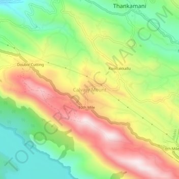
Name: Calvary Mount topographic map, elevation, terrain.
Location: Calvary Mount, Idukki, Idukki District, Kerala, 685512, India (9.80269 77.00600 9.84269 77.04600)
Average elevation: 3,097 ft
Minimum elevation: 2,198 ft
Maximum elevation: 4,150 ft
Other topographic maps
Click on a map to view its topography, its elevation and its terrain.
Shaji A M Ayyamvellil,Kattapana South Kulam
India > Kerala > Idukki > Kattappana
Average elevation: 2,982 ft
Shaji A M Ayyamvellil,Kattapana South Kulam
India > Kerala > Idukki > Kattappana
Average elevation: 2,982 ft