
Make a donation
Gear up for your next adventure:
As an Amazon Associate, this site earns from qualifying purchases at no extra cost to you.
Sterkspruit topographic map
Click on the map to display elevation.
Make a donation
Gear up for your next adventure:
As an Amazon Associate, this site earns from qualifying purchases at no extra cost to you.
About this map
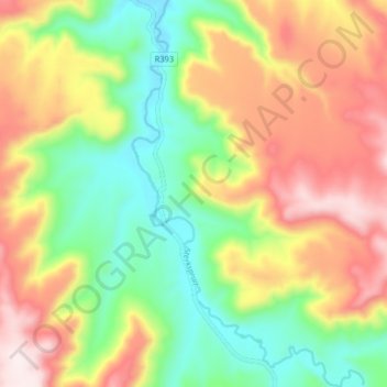
Name: Sterkspruit topographic map, elevation, terrain.
Average elevation: 6,647 ft
Minimum elevation: 5,837 ft
Maximum elevation: 7,651 ft
Make a donation
Gear up for your next adventure:
As an Amazon Associate, this site earns from qualifying purchases at no extra cost to you.
Other topographic maps
Click on a map to view its topography, its elevation and its terrain.
White City
South Africa > Eastern Cape > Joe Gqabi District Municipality > Senqu Local Municipality
Average elevation: 5,282 ft
Lady Grey
South Africa > Eastern Cape > Joe Gqabi District Municipality > Senqu Local Municipality
Average elevation: 5,915 ft
Tafelberg
South Africa > Eastern Cape > Joe Gqabi District Municipality > Senqu Local Municipality
Average elevation: 7,014 ft
Naledi
South Africa > Eastern Cape > Joe Gqabi District Municipality > Senqu Local Municipality > Naledi
Average elevation: 4,980 ft
Make a donation
Gear up for your next adventure:
As an Amazon Associate, this site earns from qualifying purchases at no extra cost to you.
Fort Hook
South Africa > Eastern Cape > Joe Gqabi District Municipality > Senqu Local Municipality
Average elevation: 5,246 ft