
Lake Hartwell topographic map
Click on the map to display elevation.
Lake Hartwell
Lake Hartwell is a man-made reservoir bordering Georgia and South Carolina and encompassing parts of the Savannah, Tugaloo, and Seneca rivers. Lake Hartwell is one of the Southeastern United States' largest recreation lakes. The lake was created by the construction of the Hartwell Dam, completed in 1962 and located on the Savannah River seven miles (11 km) below the point at which the Tugaloo and Seneca Rivers join to form the Savannah. Extending 49 miles (79 km) up the Tugaloo and 45 miles (72 km) up the Seneca at normal pool elevation, the lake comprises nearly 56,000 acres (230 km2) of water with a shoreline of 962 miles (1,548 km). The entire Hartwell "Project" contains 76,450 acres (309 km2) of land and water. I-85 bisects Hartwell Lake and makes the area easily accessible to visitors.
About this map
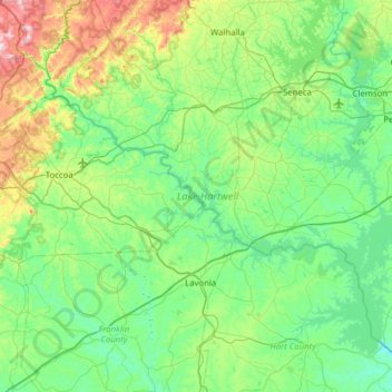
Name: Lake Hartwell topographic map, elevation, terrain.
Average elevation: 879 ft
Minimum elevation: 486 ft
Maximum elevation: 2,343 ft
Stephens County trails, hiking, mountain biking, running and outdoor activities