
Make a donation
Gear up for your next adventure:
As an Amazon Associate, this site earns from qualifying purchases at no extra cost to you.
Gliwice topographic map
Click on the map to display elevation.
Make a donation
Gear up for your next adventure:
As an Amazon Associate, this site earns from qualifying purchases at no extra cost to you.
About this map
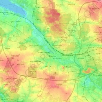
Name: Gliwice topographic map, elevation, terrain.
Location: Gliwice, Metropolis GZM, Poland (50.22721 18.54299 50.37514 18.75632)
Average elevation: 787 ft
Minimum elevation: 650 ft
Maximum elevation: 945 ft
Make a donation
Gear up for your next adventure:
As an Amazon Associate, this site earns from qualifying purchases at no extra cost to you.
Other topographic maps
Click on a map to view its topography, its elevation and its terrain.
Rysy
Poland > Lesser Poland Voivodeship > Tatra County > Brzegi
It is possible to reach the peak from the Slovak side, starting at Štrbské pleso and passing Chata pod Rysmi, a mountain chalet at an altitude of 2,250 m (7,380 ft). Between November 1 and June 15, the trail and chalet on the Slovak side are closed.
Average elevation: 6,578 ft
Make a donation
Gear up for your next adventure:
As an Amazon Associate, this site earns from qualifying purchases at no extra cost to you.
Grabiczek
Poland > Warmian-Masurian Voivodeship > Ostróda County > Wólka Lichtajńska
Average elevation: 387 ft
Smogornia / Stříbrný hřbet
Poland > Lower Silesian Voivodeship > Karkonosze County > Borowice
Average elevation: 4,383 ft
Make a donation
Gear up for your next adventure:
As an Amazon Associate, this site earns from qualifying purchases at no extra cost to you.
Kable
Poland > Greater Poland Voivodeship > Czarnków-Trzcianka County > Klempicz
Average elevation: 240 ft
Make a donation
Gear up for your next adventure:
As an Amazon Associate, this site earns from qualifying purchases at no extra cost to you.