
Make a donation
Gear up for your next adventure:
As an Amazon Associate, this site earns from qualifying purchases at no extra cost to you.
Madfeld topographic map
Click on the map to display elevation.
Make a donation
Gear up for your next adventure:
As an Amazon Associate, this site earns from qualifying purchases at no extra cost to you.
Madfeld
Der Ortskern von Madfeld erstreckt sich vor allem über die Nordseite des Schwickartsbergs (499,2 m), einem Berg der Briloner Höhen. Damit liegt Madfeld am Ostrand der Briloner Hochfläche. Diese offene Landschaft prägt das Madfelder Gebiet im Westen und Nordwesten. Nördlich des Dorfes befinden sich das Bürener Land und das Sintfeld.
Make a donation
Gear up for your next adventure:
As an Amazon Associate, this site earns from qualifying purchases at no extra cost to you.
About this map
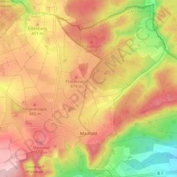
Name: Madfeld topographic map, elevation, terrain.
Average elevation: 1,444 ft
Minimum elevation: 1,037 ft
Maximum elevation: 1,739 ft
Make a donation
Gear up for your next adventure:
As an Amazon Associate, this site earns from qualifying purchases at no extra cost to you.
Other topographic maps
Click on a map to view its topography, its elevation and its terrain.
Hoppecke
Deutschland > Nordrhein-Westfalen > Hochsauerlandkreis > Brilon
Hoppecke liegt im tief eingeschnittenen Tal des gleichnamigen Flusses Hoppecke, etwa 5,5 km Luftlinie südöstlich vom Stadtzentrum Brilons entfernt. Die schon genannte Hoppecke durchfließt das Dorf in nordöstlicher Richtung. Nördlich der Ortschaft erhebt sich der 620,1 m hohe Bilstein, südlich der…
Average elevation: 1,614 ft