
Covilhã topographic map
Interactive map
Click on the map to display elevation.
About this map
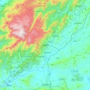
Name: Covilhã topographic map, elevation, terrain.
Average elevation: 2,530 ft
Minimum elevation: 1,325 ft
Maximum elevation: 5,410 ft
Other topographic maps
Click on a map to view its topography, its elevation and its terrain.
Teixoso
Portugal > Centro > Teixoso e Sarzedo > Covilhã
Teixoso, Teixoso e Sarzedo, Covilhã, Castelo Branco, Cova da Beira, Centro, Portugal
Average elevation: 2,280 ft
Cortes do Meio
Portugal > Centro > Covilhã > Cortes do Meio > Cortes do Meio
Cortes do Meio, Castelo Branco, Centro, 6215-121, Portugal
Average elevation: 2,474 ft
Ribeira de Caria
Ribeira de Caria, Ferro, Covilhã, Castelo Branco, Cova da Beira, Centro, 6200-571, Portugal
Average elevation: 1,440 ft