
Make a donation
Gear up for your next adventure:
As an Amazon Associate, this site earns from qualifying purchases at no extra cost to you.
Teixoso topographic map
Click on the map to display elevation.
Make a donation
Gear up for your next adventure:
As an Amazon Associate, this site earns from qualifying purchases at no extra cost to you.
About this map
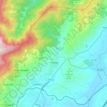
Name: Teixoso topographic map, elevation, terrain.
Location: Teixoso, Covilhã, Castelo Branco, Portugal (40.28472 -7.48580 40.35593 -7.37753)
Average elevation: 2,280 ft
Minimum elevation: 1,378 ft
Maximum elevation: 4,793 ft
Make a donation
Gear up for your next adventure:
As an Amazon Associate, this site earns from qualifying purchases at no extra cost to you.
Other topographic maps
Click on a map to view its topography, its elevation and its terrain.
Make a donation
Gear up for your next adventure:
As an Amazon Associate, this site earns from qualifying purchases at no extra cost to you.
Make a donation
Gear up for your next adventure:
As an Amazon Associate, this site earns from qualifying purchases at no extra cost to you.
Penhas da Saúde
Portugal > Castelo Branco > Covilhã
Penhas da Saúde é uma localidade no município da Covilhã, Portugal. Esta aldeia de montanha está localizada no coração da Serra da Estrela, agraciada com um belo cenário montanhoso, a uma altitude de 1.500 metros. É principalmente um resort de inverno.
Average elevation: 4,833 ft
Make a donation
Gear up for your next adventure:
As an Amazon Associate, this site earns from qualifying purchases at no extra cost to you.
Barroca Grande
Portugal > Castelo Branco > Covilhã > Aldeia de São Francisco de Assis
Average elevation: 2,238 ft
Make a donation
Gear up for your next adventure:
As an Amazon Associate, this site earns from qualifying purchases at no extra cost to you.
Make a donation
Gear up for your next adventure:
As an Amazon Associate, this site earns from qualifying purchases at no extra cost to you.
Barroca Grande
Portugal > Castelo Branco > Covilhã > Aldeia de São Francisco de Assis
Average elevation: 2,238 ft
Make a donation
Gear up for your next adventure:
As an Amazon Associate, this site earns from qualifying purchases at no extra cost to you.