
Make a donation
Gear up for your next adventure:
As an Amazon Associate, this site earns from qualifying purchases at no extra cost to you.
Palampur topographic map
Click on the map to display elevation.
Make a donation
Gear up for your next adventure:
As an Amazon Associate, this site earns from qualifying purchases at no extra cost to you.
Palampur
Birni Devi Temple: Situated at an altitude of 2240 meters, offers a manageable day trek for visitors. Local residents along the route provide guidance through the forested path leading to the Birni top. The trek typically begins from Jakhani Mata temple, accessible by car, marking the starting point for the journey to Birni Mata.
Make a donation
Gear up for your next adventure:
As an Amazon Associate, this site earns from qualifying purchases at no extra cost to you.
About this map
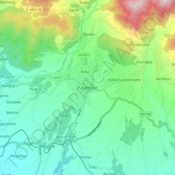
Name: Palampur topographic map, elevation, terrain.
Location: Palampur, Kangra, Himachal Pradesh, 176061, India (31.94955 76.37595 32.26955 76.69595)
Average elevation: 5,787 ft
Minimum elevation: 2,100 ft
Maximum elevation: 16,083 ft
Make a donation
Gear up for your next adventure:
As an Amazon Associate, this site earns from qualifying purchases at no extra cost to you.