
Make a donation
Gear up for your next adventure:
As an Amazon Associate, this site earns from qualifying purchases at no extra cost to you.
Kruishoutem topographic map
Click on the map to display elevation.
Make a donation
Gear up for your next adventure:
As an Amazon Associate, this site earns from qualifying purchases at no extra cost to you.
Kruishoutem
Kruishoutem ligt op de grens van Zandig Vlaanderen en Zandlemig Vlaanderen. De hoogte varieert van 11 meter tot 70 meter in het zuiden. Kruishoutem ligt in het gebied tussen Leie en Schelde.
Make a donation
Gear up for your next adventure:
As an Amazon Associate, this site earns from qualifying purchases at no extra cost to you.
About this map
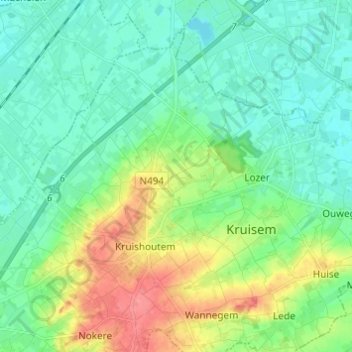
Name: Kruishoutem topographic map, elevation, terrain.
Average elevation: 75 ft
Minimum elevation: 13 ft
Maximum elevation: 226 ft
Make a donation
Gear up for your next adventure:
As an Amazon Associate, this site earns from qualifying purchases at no extra cost to you.
Other topographic maps
Click on a map to view its topography, its elevation and its terrain.