
Make a donation
Gear up for your next adventure:
As an Amazon Associate, this site earns from qualifying purchases at no extra cost to you.
Losheim am See topographic map
Click on the map to display elevation.
Make a donation
Gear up for your next adventure:
As an Amazon Associate, this site earns from qualifying purchases at no extra cost to you.
About this map
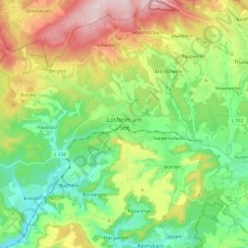
Name: Losheim am See topographic map, elevation, terrain.
Average elevation: 1,135 ft
Minimum elevation: 610 ft
Maximum elevation: 2,064 ft
Make a donation
Gear up for your next adventure:
As an Amazon Associate, this site earns from qualifying purchases at no extra cost to you.
Other topographic maps
Click on a map to view its topography, its elevation and its terrain.
Stausee Losheim
Deutschland > Saarland > Landkreis Merzig-Wadern > Losheim am See
Average elevation: 1,086 ft
Make a donation
Gear up for your next adventure:
As an Amazon Associate, this site earns from qualifying purchases at no extra cost to you.
Naturschutzgebiet Wadrilltal
Deutschland > Saarland > Landkreis Merzig-Wadern > Wadern
Average elevation: 1,060 ft
Make a donation
Gear up for your next adventure:
As an Amazon Associate, this site earns from qualifying purchases at no extra cost to you.
Fallenseifenberg
Deutschland > Saarland > Landkreis Merzig-Wadern > Wadern
Average elevation: 1,539 ft
Reidelbach
Deutschland > Saarland > Landkreis Merzig-Wadern > Wadern > Wedern
Average elevation: 1,296 ft
Make a donation
Gear up for your next adventure:
As an Amazon Associate, this site earns from qualifying purchases at no extra cost to you.
Schimmelkopf
Deutschland > Saarland > Landkreis Merzig-Wadern > Weiskirchen
Average elevation: 1,985 ft
Scheiden
Deutschland > Saarland > Landkreis Merzig-Wadern > Losheim am See > Scheiden
Average elevation: 1,552 ft
Rissenthal
Deutschland > Saarland > Landkreis Merzig-Wadern > Losheim am See > Rissenthal
Average elevation: 1,001 ft
Make a donation
Gear up for your next adventure:
As an Amazon Associate, this site earns from qualifying purchases at no extra cost to you.
Pillinger Hof
Deutschland > Saarland > Landkreis Merzig-Wadern > Perl > Borg
Average elevation: 1,040 ft