Geolocate

Banks topographic map

Click on the map to display elevation.

About this map

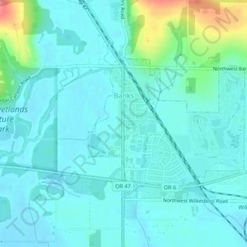
Name: Banks topographic map, elevation, terrain.

Location: Banks, Washington County, Oregon, 97106, United States (45.60876 -123.11985 45.62287 -123.09537)

Average elevation: 230 ft

Minimum elevation: 171 ft

Maximum elevation: 515 ft

Washington County trails, hiking, mountain biking, running and outdoor activities

Other topographic maps

Click on a map to view its topography, its elevation and its terrain.

Henry Hagg Lake

United States > Oregon > Washington County

Average elevation: 420 ft

Gales Creek

United States > Oregon > Washington County

Average elevation: 420 ft

Buxton

United States > Oregon > Washington County

Average elevation: 479 ft

Carnation

United States > Oregon > Washington County > Forest Grove

Average elevation: 180 ft

Gear up for your next adventure:

🎒Day Hiking Backpack - Lightweight backpack perfect for day trips and outdoor adventures
📡GPS Antenna Upgrade - Enhance GPS reception in remote terrain
📱Heavy-Duty Phone Cases - Drop-proof and waterproof protection for outdoor navigation
👓Polarized Sunglasses - Outdoor sunglasses for glare reduction
🍳Camping Cook Set - Complete cookware for outdoor meals

As an Amazon Associate, this site earns from qualifying purchases at no extra cost to you.