
Make a donation
Gear up for your next adventure:
As an Amazon Associate, this site earns from qualifying purchases at no extra cost to you.
Wellsboro topographic map
Click on the map to display elevation.
Make a donation
Gear up for your next adventure:
As an Amazon Associate, this site earns from qualifying purchases at no extra cost to you.
About this map
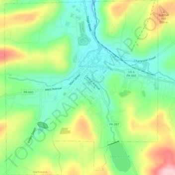
Name: Wellsboro topographic map, elevation, terrain.
Location: Wellsboro, Tioga County, Pennsylvania, United States (41.72468 -77.32393 41.76246 -77.28083)
Average elevation: 1,506 ft
Minimum elevation: 1,243 ft
Maximum elevation: 1,926 ft
Tioga County trails, hiking, mountain biking, running and outdoor activities
Make a donation
Gear up for your next adventure:
As an Amazon Associate, this site earns from qualifying purchases at no extra cost to you.
Other topographic maps
Click on a map to view its topography, its elevation and its terrain.
Mainesburg
United States > Pennsylvania > Tioga County > Sullivan Township
Average elevation: 1,565 ft
Middlebury Center
United States > Pennsylvania > Tioga County > Middlebury Township
Average elevation: 1,516 ft
Make a donation
Gear up for your next adventure:
As an Amazon Associate, this site earns from qualifying purchases at no extra cost to you.
Roaring Branch
United States > Pennsylvania > Tioga County > Union Township
Average elevation: 1,539 ft
Wellsboro Junction
United States > Pennsylvania > Tioga County > Delmar Township
Average elevation: 1,463 ft
Make a donation
Gear up for your next adventure:
As an Amazon Associate, this site earns from qualifying purchases at no extra cost to you.
Roaring Branch
United States > Pennsylvania > Tioga County > Union Township
Average elevation: 1,539 ft
South Mountain
United States > Pennsylvania > Tioga County > Hamilton Township
Average elevation: 1,650 ft